With climate change driving more frequent extreme weather, floods are a significant concern for estates managers. In England alone, over 6.3 million properties are at risk from flooding, a number projected to rise to 8 million by 2050 as climate change intensifies. This surge in flood risk is not just a concern for homeowners but poses significant challenges for those responsible for safeguarding buildings, infrastructure, and occupants.
Traditional flood risk management methods are often reactive and based on outdated data, meaning they’re no longer sufficient. Instead, estates managers must get their hands on modern, data-driven approaches that offer real-time insights and predictive capabilities.
Thankfully, we’re at the heart of this digital change and have been helping estates managers turn complex site and building data into actionable insights for decades. From mapping vulnerable assets to identifying safe zones, digital tools are transforming how flood resilience is planned and delivered. In this blog, we’re delving into how utilising this technology can give your estate the foresight and confidence it needs to stay protected before the next storm hits.
The Risk of Outdated Systems
In January this year, the UK’s National Audit Office reported a staggering £49 billion maintenance backlog across government buildings, including schools, hospitals, and prisons, leading to significant service disruptions and safety risks. This chronic underinvestment, coupled with outdated systems, exposes estates to escalating flood risks.
Here are the key risks involved:
- Blind Spots: Static data prevents real-time flood awareness.
- Wasted Resources: Maintenance and mitigation can be overlooked.
- High Vulnerability: Ageing drainage and infrastructure increase flood risk.
- Compliance Risks: Outdated systems may breach safety and legal standards.

The Power of Data in Flood Resilience
Digital tools are revolutionising how estates managers plan for and respond to flood risk. For example, solutions like our Integrated Dashboards, Geographic Information System (GIS) mapping, and digital twinsallow teams to access detailed, up-to-date information about every asset and site feature. These unified datasets can consolidate building floor plans, drainage systems, topography, and historical flood patterns, which provide a comprehensive view of potential weaknesses.
These insights make it possible to prioritise preventative measures, identify safe zones for critical equipment, and model how water might flow across a site under different rainfall or storm scenarios. For example, digital twins bring site and building data to life in a dynamic, interactive environment. Every element of a building is represented digitally with accurate spatial and functional attributes, allowing you to highlight areas at greatest risk and enable targeted interventions. With these tools, decision-making shifts from reactive to proactive, helping estates managers reduce damage, protect occupants, and ensure business continuity even during extreme weather events.
Using External Areas for Flood Prevention
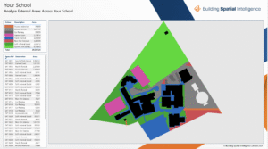
The External Areas view of our Integrated Dashboards gives estates managers a clear, colour-coded breakdown of their outdoor provision, including playgrounds, sports fields, and car parks, making it easier to see how each type of surface interacts with rainfall. It allows you to distinguish between permeable areas, like grass or pitches, and impermeable zones, like tarmac, to predict where water is most likely to accumulate during heavy storms. This visibility enables proactive action, such as directing surface water away from buildings, maintaining drains in high-risk areas, or planning for green infrastructure like rain gardens or permeable paving. In practice, it means external spaces aren’t just managed for compliance and daily use; they also become part of a wider flood prevention strategy.
Turning Insights into Action: Practical Applications of Integrated Data
Having data is pointless without turning it into actionable insights that help estates managers plan, protect, and respond to flood risks. The following applications demonstrate how modern technology can make your estate more resilient and proactive in the face of extreme weather.
1. Mapping Vulnerable Assets
Flood risk data can be integrated with detailed building information, allowing estates managers to pinpoint which assets are most at risk. For example, the Environment Agency’s National Flood Risk Assessment (NaFRA) offers high-resolution maps showing potential flood depths and the projected impact of climate change. This enables teams to prioritise protective measures and resource allocation effectively.
2. Identifying Safe Zones
Digital mapping makes it possible to identify areas within a site that are less likely to be affected by flooding. These safe zones are critical for planning evacuation routes, relocating essential equipment, and maintaining business continuity during extreme weather.
3. Modelling Drainage and Topography
Advanced modelling tools can simulate how water will flow across a site under different conditions, helping estates managers anticipate flood scenarios and assess drainage effectiveness. This proactive approach means that teams can implement necessary improvements, like upgrading drains or redirecting water flow, before flooding occurs.
Forecasting Flood Resilience with BIM, AI, and Data Integration
Beyond the above, predictive flood resilience is becoming possible by integrating BIM models with environmental, infrastructure, and weather datasets, enhanced with AI and machine learning. BIM provides spatially precise building and asset data, while AI can process rainfall forecasts, soil moisture sensors, drainage network performance, and historical flood events to generate risk scores, alert systems, and scenario simulations. For example, AI models can estimate how a combination of heavy rainfall and blocked drains may affect specific floors or equipment locations, and simulate interventions like sandbag placement or temporary water diversion.
Using this data integration, estates managers can create forecasting reports consisting of:
- Executive Summary – Key risks, vulnerable assets, and recommended actions.
- Site Overview – Maps, digital twin visuals, and high-level descriptions of building and external areas.
- Data & Methodology – Sources used (BIM, GIS, LiDAR, weather data), modelling assumptions, and scenario definitions.
- Findings – Vulnerable zones, predicted flood depths, flow paths, safe zones, and potential impacts. Include charts, maps, and annotated digital twin snapshots.
- Recommendations – Preventative measures, infrastructure upgrades, green infrastructure, and emergency procedures.
- Forecasting & Scenario Planning – AI-based predictions, what-if scenarios, and early-warning thresholds.
This structure allows estates managers to communicate technical findings clearly to decision-makers while supporting actionable steps and planning for future climate scenarios.
Protect Your Assets Before the Next Storm Hits
Storms may be unpredictable, but your flood resilience strategy doesn’t have to be. With our unified datasets, you’ll know exactly where your estate is most at risk and what to do about it. Think of it as an umbrella for your buildings: always handy, always reliable!
Ready to protect your estate? Book a consultation with our experts and let’s get started.